The author of the "Historical Sketches of McPhaul's Mill" below is unknown, and may have been composed by the North Carolina State Department of Archives and History. The sketch is transcribed from a booklet printed in 1959 in Lumberton, NC, for an unveiling of a roadside marker designating the location of McPhaul's Mill in old Robeson (now Hoke) County, NC. If the author is known to anyone reading this article, please inform me of their identity.
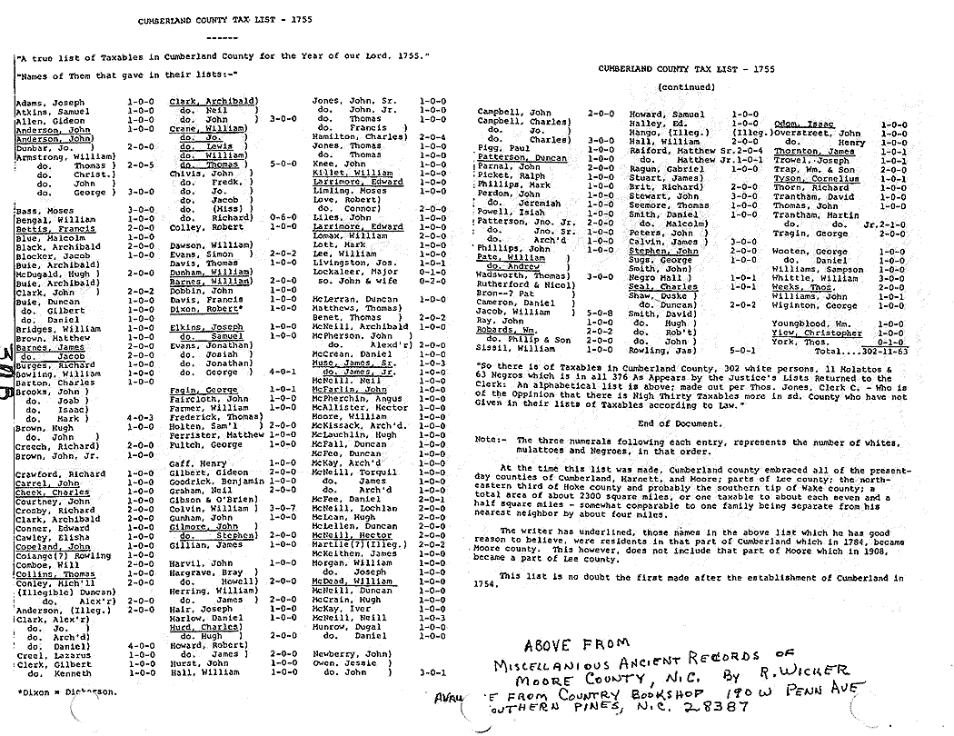
Note: The earliest appearance of the name "John McPhoile" (along with Dugald McPhoile) appears in a request by the men of the Cape Fear settlement to the Synod of Argyll asking for a minister, dated November of 1748. "John McPhoile" is found later in Bladen County land abstracts as taking up 100 acres in 1753 in what is now Cumberland County. The name "John McFall" appears again in Cumberland County records in September 28, 1754—the year Cumberland County was formed from Bladen County—at which time he owned land adjacent to James and Thomas Rutherford in Cumberland County, NC. Whether McPhaul lived upon this land is unknown. The name "Duncan McFall" appears in the Cumberland County tax list of 1755. It appears that John McPhaul may have moved from Cumberland into Bladen between 1755 and 1768. The earliest date that his name appears in surviving Bladen County deeds is 1754, and then in 1768 he is found buying land from his future wife, the widow Ann Perkins (Her name is Marrion in her will and, together with tax records and Robeson County deeds, her maiden name is now believed to have been Johnston) who lived at what was to become the McPhauls Mill area, but I have not checked any other records of early Bladen for him.
Historical Sketches of McPhaul's Mill
The first pioneer settlers in the section of North Carolina radiating from what later came to be known as McPhaul's Mill were English and not Scottish as has been the popular belief. These settlers were immigrants from Virginia and the section of North Carolina now embraced by the counties of Franklin, Warren, Nash, and Edgecombe. Among the names borne by these immigrants we find Reddin, Kearsey, Raiford, Caddell, Hall, Moore, Atkins, Thompson, Kitchen, Cole, Drake, Humphrey, Bridger, Lowrie, Perkins, and Beatties [Reddin, Caddell, Hall, Moore, Atkins, Thompson, Kitchen, Cole, and Lowrie are all subsets of Scottish clans, many from the lowlands; Beatties, sometimes spelled 'Bettis' or 'Bottis', also is a Scottish name. –SE] — hence, Beatties' (now Gilchrist's) Bridge. Some of these families existed almost entirely by hunting while others raised stock which they allowed to roam at will. These people chose to move inland ahead of the permanent settlements while the Scots were interested in the establishment of churches, schools, and enterprises which go hand in hand with lasting and permanent settlement. The Scottish settlers who followed closely called them "Buckskins" due to the habit of their dress.
Sometime prior to the year 1761, John McPhaul, who according to one account was from one of the Hebrides Islands off the coast of Scotland, arrived at Cross Creek (now Fayetteville), North Carolina. [The name 'John McPhoile' and 'Dugald McPhoile' are both on a Cumberland County bond for a minister dated 1748, and a Bladen County land warrant for 'John McPhoile' for one hundred acres is dated 1753 but does not say where it was in Bladen. The date of his 100-acre grant "by his Majesty's letter patent" was 1756 and was located "on a branch of Rockfish Creek on the Wagon Road," according to a 1771 Cumberland County deed. So it appears John McPhaul may have had lands in both counties at the same time in the early 1750s.] He was accompanied by his son, Neill McPhaul. Leaving their fellow emigrants in the Cross Creek settlements of the upper Cape Fear section, John McPhaul and his son, Neill McPhaul, followed the high ground southward and managed to effect a crossing of the turbid Big Raft Swamp somewhere in the vicinity of what is now Antioch Church community. The Big Raft Swamp presented quite a formidable barrier in those days and tradition has it that John McPhaul was the first Scotsman to effect a crossing [There is in the Robeson County deeds and mention of such a crossing near McPhauls Mill Swamp (aka Litte Raft Swamp) called "McPhauls Crossing" but unfortunately I did not write down the deed's location in the records, but the citation bears the claim out that the McPhauls made the crossing there. –SE].
Proceeding only a short distance further, they came to what is now called Little Raft Swamp but which has also been known as Lowrie's Swamp, McPhaul's Mill Swamp, Branch of the Raft Swamp, and Mill Prong of the Raft Swamp. Here they found a tiny settlement around a tavern kept by a widow and her comely daughter — Ann Perkins and Mary Perkins. [Ann's name is Marrion in her will, though 'Marrion', 'Marron', 'Marion', 'Marian' and 'Mary Ann' are interchangeable in that there was no standardized spelling at this time. Research in Robeson County deeds has revealed that she was born Marrion Johnston, daughter of Solomon Johnston, Sr., who may have come from Viriginia but who owned land in Cumberland County in 1757.] It was here that they also found contentment for in time Ann Perkins became the wife of John McPhaul and "Pretty Molly" [or "Pretty Polly"] Perkins married Neill McPhaul. Thus was founded the McPhaul family in North Carolina.
Ann Perkins was granted fifty acres of land "lying on a branch of the Raft Swamp" by patent dated April 20, 1767 [She also was granted 100 acres in 1772, NC Grant #351, "on Beaverdam branch So of the Raft Swamp which is a branch of Richland Swamp". Depending on how this sentence is read, this early deed is in error because Raft Swamp is not a branch of Richland Swamp but flows more or less parallel to it. Beaverdam branch may have been a branch on the south side of the Raft Swamp, however.] and John McPhaul was granted one hundred acres "lying on the mill prong of the Raft Swamp" by patent dated December 22, 1770. The grant to John McPhaul reveal that the two tracts of land were adjacent.
Old John McPhaul had been a miller in the old country and had brought his millstones with him. He and his son, finding the run of the Little Raft admirably suited to their purpose, soon built a grist mill which drew customers from far and near among the many Scottish Emigrants who eventually settled thickly there between the waters of the Cape Fear and Pee Dee Rivers. With the passing years, the mill and tavern became a gathering place for the community.
During the Revolutionary War, McPhaul's Mill and Tavern became and important place or rally for the Loyalists and Tories. Rev. E.W. Caruthers in his Interesting Revolutionary Incidents and Sketches of Character Chiefly in the Old North State states, "Capt. Neill McFall, or, according to the Scottish orthography, McPhaul, lived on the Raft Swamp, and kept a mill. His house was headquarters for the Tories all over that region and was the place of rendezvous before and after every expedition in which the different corps united". In another place he labels McPhaul's Mill the "place of general rendezvous for all the Tories east of the Yadkin River at least during the latter part of the Revolutionary War."
The three following incidents will serve to illustrate the military activity at McPhaul's Mill during the war.
Colonel David Fanning, notoriously ruthless but colorful leader of the Tories attacked Pittsboro on July 17, 1781 while county court was in session. He captured forty-four prisoners (officers of the court, military officers, and priminent citizens). This party encamped at McPhaul's Mill while enroute to deliver the prisoners to Major Craig, the British commander and Wilmington.
This same officer, in conjunction with Scottish Loyalists under the command of Colonels Hector McNeill, Duncan Ray, and Archibald McDougald, captured the patriot governor Thomas Burke and other prominent officials at the capital of Hillsboro on Sept. 2, 1781. McPhaul's Mill was again one of the places of encampment while enroute to deliver the prisoners to the British officers at Wilmington. This capture of the governor was one of the most remarkable feats accomplished by the Tories during the course of the war.
General Griffith Rutherford encamped at McPhaul's Mill while leading his patriot army in the campaign against the Tories in Oct., 1781.
The following is a written account of the Battle of McPhaul's Mill. It has been taken from Interesting Revolutionary Incidents and Sketches of Character Chiefly in the Old North State. This history was written by Rev. E.W. Caruthers and published by Hayes & Zell, Philadelphia in 1854.
Battle of McPhaul's Mill
"Colonel David Fanning and the Tories remained at Wilmington three days, during which time he received a commission from Major Craig, of Lieutenant Colonel, and a suit of rich regimentals, with suitable epaulettes, sword and pistols. He set out on his return to Chatham, and at McFall's Mill, having encamped, intelligence was received by express that Colonel Thomas Wade, of Anson County, with six hundred and sixty men, were at Beatties' Bridge, on Drowning Creek, twenty miles south of McFall's Mill. The express reached the camp about eight o'clock at night. Fanning ordered his men to mount their horses and march immediately. At the dawn of day, ten miles north of Beatties' Bridge, they came up with Colonel Hector McNeill, having with him three hundred men; the whole number then amounted to three hundred and forty. Fanning took the command, and soon learning that Colonel Wade had crossed the bridge to the eastern side of Drowning Creek, he turned to the right, and passed up a swamp to a crossway, expecting to find Colonel Wade between that swamp and the creek. The crossway was distant about three-quarters of a mile from Beatties' Bridge. Fanning halted at the crossway and gave notice of the order of battle. His men were directed to pass the crossway, two deep, and all having got over, Colonel McNeill was ordered to turn down the swamp to the left towards the bridge, to cut off Wade's retreat in that direction. He was ordered not to bring his men into action unless Fanning should be hard pressed and in danger of being defeated, but to watch the progress of the battle, and if Wade should be routed, by securing the pass to the bridge, to prevent his retreat, and capture as many prisoners as possible. Fanning was to turn to the right from the end of the crossway with all the other men, and they were directed to follow him in the same order in which they passed the crossway, until he should reach the extreme left of Wade's line, when upon a signal to be given by him, they were to dismount and commence the fight. Eleven men were left to guard the crossway and prevent the escape of the horses, the swamp being impassable for miles except at this crossway.
These orders being given, Fanning, preceding his column, passed the crossway, his men following him. As soon as he passed, he discovered Wade's men drawn up on the top of the hill in line of batttle. The ground was favorable for his attack. There was no undergrowth of bushes, and the pines were thinly scattered on the slope of the hill. Fanning immediately perceived the injudicious position which Wade had taken and confident of victory, rode on to the left of Wade's line. Before, however, he had proceeded as far as he had intended, one of his men was thrown from his horse, and in the act of falling his gun fired. Instantly Wade's line fired, and eighteen horses belonging to Fanning's men were killed. Fanning wheeled, gave the signal to dismount, which was instantly observed by his men, who poured in a deadly fire upon Wade's line. Fanning rode along his line in front and ordered his men to advance upon every fire, and they continued to advance and fire until they got within twenty-five yards of Wade's line, when it suddenly broke, and the men fled in the utmost confusion. Fanning pursuing with with activity, and expecting that their retreat by the bridge would be cut off by Col. McNeill he had no doubt of taking them all prisoners. To his astonishment, he found that Col. McNeill had not occupied the ground to which he was ordered; that he had passed down the right of Wade's line, only a short distance, and left the way to the bridge open. Fanning pressed on the fugitives, and soon took forty-four prisoners. He then directed a few of his men to mount, and with them he pursued Wade at full speed, for two or three miles. But Wade had fled at full speed, and Fanning could not overtake him.
During this fight, as well as upon every other occasion, Fanning displayed the most daring courage. Dressed in rish British uniform, he rode between the lines furing the fight, and gave his orders with the utmost coolness and presence of mind. It is strange that he had not been selected by some of Wade's men, as he was at the close of the fight, not twenty yards distant from them. He did not lose one of his men, only two or three were slightly wounded. As he ascended the hill, Wade's men shot over his, and when he approached the summit, Wade's men were so panic struck that they fired without aim. Wade lost twenty-seven killed, and of the prisoners taken, several died of their wounds."
Capt. Neill McPhaul was wounded in some of the fighting during the latter part of the war and we loose track of him in Charleston, S.C. [Read his daughter's account of his horrible death. He is said to have been buried in Charleston but I cannot tell if that is true or, if so, whether his grave was marked.], to which place he and so many loyalists fled for refuge. Whether he died and was buried there, we have been unable to ascertain. His property was confiscated for the part he played in the service to the king. His wife, Mary Perkins McPhaul, petitioned for a subsistence for herself and children and, as a result, the lands of Neill McPhaul were declared to descend to his male heirs by a special act of the General Assembly of the State of North Carolina passed in the year 1789.
After the war ended, McPhaul's Mill prevailed as a center of community life. A sawmill, a distillery, and a cotton gin were added to the grist mill and tavern and the site became a voting precinct. Here the people celebrated the fifth of January as old Christmas Day and the twelfth of January as old New Year's Day with the then national game of shinney (golf), whiskey drinking, and horse racing. The tavern became a convenient stage stop on the old stage road between Fayetteville and Cheraw, S.C. It was this road that General LaFayette traveled during his tour of the South in 1825 and the tavern was a rest stop for him. Another ancient thoroughfare, the Camden Road, passed the mill and we can see that the people there were in direct touch with all important towns in the state and in upper South Carolina.
From the records of Antioch Church and from the diary of Rev. Hector McLean, we learn that after the burning and dissolution of Old Raft Swamp Presbyterian Church and prior to the organization of Antioch Church in 1833, the people assembled occasionally at McPhaul's Mill — about midway between Raft Swamp Church and the present church of Antioch. Here they had the gospel preached to them in the grove by itinerant ministers among whom we note Revs. Angus McDiarmid, Colin McIver, John McIntyre, and Archibald Buie. Lawyer John Gilchrist and Randal Currie organized a Sunday School here and several unsuccessful attempts were made to reorganize the church at this place. Disagreement over the question of prohibition caused a split in the congregation and some members united with other churches — the balance remaining to form the nucleus of the present church of Antioch Church.
It was not until about the time of the Civil War that McPhaul's Mill and Tavern ceased to be the center of activity within a radius of twenty-five or thirty miles — the march of progress finally passing it by.
On April 30, 1933, a marker was unveiled at the site of McPhaul's Mill and Tavern. This was erected mainly through the efforts of Miss Etta Brown, state historian of the Daughters of American Colonists. It is of native brown sandstone and on either side stand the more recent mill stones which were quarried near Carthage over one hundred and twenty-five years ago and brought down to replace the old Scottish stones, a fragment of which was discovered in the mire of the swamp and was incorporated in the marker. A tablet bears this inscription: "Site of McPhaul's Mill and Tavern, rallying ground during the Revolution. Near here took place the Skirmish of McPhaul's Mill and Little Raft Swamp. This memorial is erected to those valiant pioneers who laid the foundation for the culture and progress of our Cape Fear section."
The members of this family as well as the people of this community may well be proud today as the North Carolina State Department of Archives and History recognizes the historical significance of this place with the erection and unveiling of a roadside marker to McPhaul's Mill.